Day 4
+7
Blakeway4
Edge
emgmod
anarchy0029
Sky Guy
Saathoff
Thomas
11 posters
Page 1 of 1

Day 4
![]() by Thomas 25th April 2010, 18:55
by Thomas 25th April 2010, 18:55

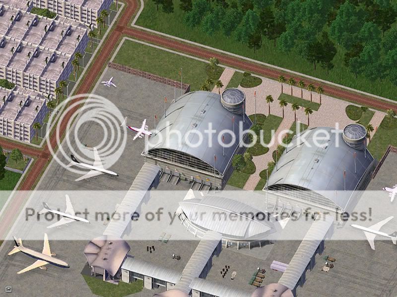
Welcome to Woking International Airport, where today we will be discussing how to build good transport networks in your cities, and how you use different mass transit types in your cities.
1a. Do you use the NAM?
1b. If yes, do you use Simulator Z? If you answered no to Q1, skip this question.
2a. How does your Road network connect? Please describe what your system is for roads (Motorways, A-Roads, B-Roads, C-Roads, Minor Roads etc).
2b. Do you use Rural Highways? If so, describe how you use them in your country.
3a. What is your general Rail network like? Please describe how general Rail is used in your country.
3b. Do you use High Speed Rail? If you do, please describe how you use it.
4a. Do you use subway networks/Elevated Railways? If you do, please describe how you use them, and whether you link the two systems.
4b. Do you use the GLR system? If so, describe how you use it.
Last edited by Thomas on 25th April 2010, 19:37; edited 2 times in total

Thomas- Overlord of Eurasia
- Posts : 5849

Re: Day 4
![]() by Saathoff 25th April 2010, 19:33
by Saathoff 25th April 2010, 19:33
1a. Do you use the NAM? Yes
1b. If yes, do you use Simulator Z? No
2a. How does your
Road network connect? City-Streets(35mph) Roads/Avenues(40mph), Highways(65mph), Major Highways like U.S. interstates (75mph)
2b. Do you
use Rural Highways? Yes, in Escambia rural roads are common. They crisscross the countryside.
3a.
How does your Rail network work? Passenger rail is common in URE. Many cities are connected by such rails. And Industral rails are used alot on the coasts and because rail transportation is much cheaper to ship goods. Due to the mountains in the middle of the country semi traffic is used there
3b. Do you use High Speed Rail? Connects Glauchau, Freeport, Algona, Halifax, Canmore & New Manchester. and other smaller cities on route
4a. Do you use subway
networks/Elevated Railways? Yes they link parts of the downtown metro areas in every big city
4b. Do you use the GLR system? Forgot what GLR was?
Last edited by Saathoff on 25th April 2010, 19:46; edited 1 time in total

Saathoff- Prime Minister
- Posts : 2373
Thomas- Overlord of Eurasia
- Posts : 5849
Re: Day 4
![]() by Sky Guy 25th April 2010, 19:59
by Sky Guy 25th April 2010, 19:59
1a- Yes
1b- I don't think so.
2a- Most of my road network is a mess- just like the real southeast asia. I try and put a lot of highways through it, and a lot of small crowded streets.
2b- yes- I use the RHW as my nations main highway that goes along the coast.
3a- There is a main rail-line (one track in either direction) following the coast, it is used by mostly industrial, but lots of passenger traffic follow it too. The old railway (1 track) follows a similar course, but is rarely used, except far up the Kapuas River.
3b- The only highspeed rail is currently under construction. It connects the tri cities area together with the airport. another line is also in development across the border.
4a- Subway and Elevated Rail are used in most major cities
4b- There is only one or two cities that use GLR, mainly because of hills.

Sky Guy- Chargé d'Affaires
- Posts : 1185
Age : 31
Re: Day 4
![]() by anarchy0029 25th April 2010, 20:05
by anarchy0029 25th April 2010, 20:05
1a. Do you use the NAM? Always
1b. If yes, do you use Simulator Z? No
2a. How does your Road network connect? City Streets & Suburbia Roads 25 - 35 mph, Roads and Parkways 35 - 55, Highways 55 - 70mph (same applies to U.S. Highway systems)
2b. Do you use Rural Highways? Yes, mainly arond the outskirts of the city or a residential area of a major city.
3a. What is your general Rail network like? In Hypertrophy there is commuter rail from North throught south end of the city. However, there is a vast network of commuter rails which all terminates to Damiskonos. Industiral rail is the most common to transport goods from Hypertrophy to Gartlan, Valentina to Ft. Matejeck, From Damoskinos to Hypertrophy. City of Gartlan Serves as a hub to industrial rail transports, since the city lies in the central portion of the kingdom. It give pure access to all other cities.
3b. Do you use High Speed Rail? The first high speed rail was initiated in 1999. Running from Hypertrophy to Damoskinos. The completion finished in 2004, and it commutes more than 6.7 million passengers a year. In 2006 The Pacific Extension Line which runs from Hypertrophy to Damoskinos via the City of Valentina broke ground and the project was completed in September 2009. Now you can travel from Damoskinos to Hypertrophy in a matter of 3 hours compared to driving for 6 hours.
4a. Do you use subway networks/Elevated Railways? In both the City of Hypertrophy and Damoskinos, subways are a huge necessites. Cities that are over a million should have a rapid transit system. However both subway lines only run within city limits.
4b. Do you use the GLR system? Some portions of Hypertrophy uses GLR, as well as Damoskinos. However, in Gartlan and Valentina the city utilizes GLR because of its population is under a million.

anarchy0029- Counsel
- Posts : 754
Age : 47 -

Re: Day 4
![]() by emgmod 25th April 2010, 20:08
by emgmod 25th April 2010, 20:08
1a. Do you use the NAM? Yes.
1b. If yes, do you use Simulator Z? If you answered no to Q1, skip this question. Yes, the latest Beta version.
2a. How does your Road network connect? Please describe what your system is for roads (Motorways, A-Roads, B-Roads, C-Roads, Minor Roads etc). Grade separated highways have a speed limit of 56-75 mph(90-120 km/hr). Other highways have a speed limit of 31-56 mph(50-90 km/hr) Roads and avenues have a speed limit of 31-37 mph(50-60) km/hr) City streets have a nationwide set limit of 31 mph(50 km/hr) Suburban streets may have lower speed limits.
2b. Do you use Rural Highways? If so, describe how you use them in your country. Yes. They are used for major intercity routes and city freeway networks. I use them as much as possible over Maxis highways, unless the RHW can't do something.
3a. What is your general Rail network like? Please describe how general Rail is used in your country. Most tracks are owned by the government, with private train companies running on the tracks. The government operates intercity rail between many large cities, with the exception of the Sunset Coast Line. Commuter trains sometimes run on government tracks, or have built private rights of way.
3b. Do you use High Speed Rail? If you do, please describe how you use it.I use High Speed Rail and this wonderful Rail-HSR converter to create a partial HSR network, kind of like Acela Express. It connects Colbitz, Daloa, and Strathmore.
4a. Do you use subway networks/Elevated Railways? If you do, please describe how you use them, and whether you link the two systems.Yes. I use them to connect Downtown with suburbs using a train system. I link the two systems together for flexibility. Sometimes, I use subway for the Big Dig lots.
4b. Do you use the GLR system? If so, describe how you use it.Yes. I use it for making Light Rail, historic streetcars, and rapid transit tracks parallel to rail tracks.
Last edited by emgmod on 26th April 2010, 02:26; edited 1 time in total

emgmod- High Commissioner
- Posts : 1536
Re: Day 4
![]() by Thomas 25th April 2010, 20:22
by Thomas 25th April 2010, 20:22
1a. Do you use the NAM?
Yes.
1b. If yes, do you use Simulator Z? If you answered no to Q1, skip this question.
I'm not actually sure...
2a. How does your Road network connect? Please describe what your system is for roads.
Ollingdale currently has no motorways.
A-Roads (dual carriageway) cross the main 3 islands, including from the Govt district to the CBD. Speeds are between 50mph and 70mph.
B-Roads are the key single-lane roads that link towns and villages on all the islands. Speeds are between 30mph and 50mph.
C-Roads are any other roads, mainly roads that are named, like Windsor Street. Speeds are between 20mph and 30mph.
2b. Do you use Rural Highways? If so, describe how you use them in your country.
No, I tried using it but I have no idea how to do it right.
3a. What is your general Rail network like? Please describe how general Rail is used in your country.
There is one mainline rail between Ollingdale City and Woking, and 2 lines in the capital, from the industrial district to the CBD and city centre. The rail network is owned by the Government, and will expand rapidly this year.
3b. Do you use High Speed Rail? If you do, please describe how you use it.
No.
4a. Do you use subway networks/Elevated Railways?
No.
4b. Do you use the GLR system? If so, describe how you use it.
Yes, there is one in the CBD, one going from the CBD to the Govt distict, one that crosses from the industrial east to the residential west and one that goes around the suburban town north of the main city.
Thomas- Overlord of Eurasia
- Posts : 5849
Re: Day 4
![]() by emgmod 25th April 2010, 20:48
by emgmod 25th April 2010, 20:48
I would recommend that everybody switches to the latest Simulator Z Beta, as it's basically better and more realistic. The download is at the bottom of the post explaining why it's better.
emgmod- High Commissioner
- Posts : 1536
Re: Day 4
![]() by Edge 25th April 2010, 21:08
by Edge 25th April 2010, 21:08
1a. Do you use the NAM?
Yes.
1b. If yes, do you use Simulator Z? If you answered no to Q1, skip this question.
Yes.
2a. How does your Road network connect? Please describe what your system is for roads (Motorways, A-Roads, B-Roads, C-Roads, Minor Roads etc).
Motorways--- RRI has a series of highways/motorways that run all over the island nation.
A-Roads--- Avenue-type roads, mainly found in larger cities.
B-Roads--- (What is called by SC4 as a "road", found commonly in large and medium sized cities.
C-Roads--- All suburban streets found in smaller communities.
Minor Roads--- Streets in very small rural communities.
2b. Do you use Rural Highways? If so, describe how you use them in your country.
No, but the RRI DOT has discussed incorporating it into our highway network.
3a. What is your general Rail network like? Please describe how general Rail is used in your country.
Heavy rail travels all across the country; in both freight and passenger form.
3b. Do you use High Speed Rail? If you do, please describe how you use it.
RRI used to, until the DOT could no longer afford it. It may be re-introduced in the future, though.
4a. Do you use subway networks/Elevated Railways? If you do, please describe how you use them, and whether you link the two systems.
Yes, we connect the two and our GLR system together. It is essential in our metropolitan areas.
4b. Do you use the GLR system? If so, describe how you use it.
Yes, GLR is very common in the metropolitan areas of cities, as well as the suburbs, and connects to our EL Rail/subway networks.
Yes.
1b. If yes, do you use Simulator Z? If you answered no to Q1, skip this question.
Yes.
2a. How does your Road network connect? Please describe what your system is for roads (Motorways, A-Roads, B-Roads, C-Roads, Minor Roads etc).
Motorways--- RRI has a series of highways/motorways that run all over the island nation.
A-Roads--- Avenue-type roads, mainly found in larger cities.
B-Roads--- (What is called by SC4 as a "road", found commonly in large and medium sized cities.
C-Roads--- All suburban streets found in smaller communities.
Minor Roads--- Streets in very small rural communities.
2b. Do you use Rural Highways? If so, describe how you use them in your country.
No, but the RRI DOT has discussed incorporating it into our highway network.
3a. What is your general Rail network like? Please describe how general Rail is used in your country.
Heavy rail travels all across the country; in both freight and passenger form.
3b. Do you use High Speed Rail? If you do, please describe how you use it.
RRI used to, until the DOT could no longer afford it. It may be re-introduced in the future, though.
4a. Do you use subway networks/Elevated Railways? If you do, please describe how you use them, and whether you link the two systems.
Yes, we connect the two and our GLR system together. It is essential in our metropolitan areas.
4b. Do you use the GLR system? If so, describe how you use it.
Yes, GLR is very common in the metropolitan areas of cities, as well as the suburbs, and connects to our EL Rail/subway networks.

Edge- Chargé d'Affaires
- Posts : 1152
Re: Day 4
![]() by Thomas 25th April 2010, 21:17
by Thomas 25th April 2010, 21:17
emgmod wrote:I would recommend that everybody switches to the latest Simulator Z Beta, as it's basically better and more realistic. The download is at the bottom of the post explaining why it's better.
What is that image below the main post? The software looks incredible - is it available to download?
Thomas- Overlord of Eurasia
- Posts : 5849
emgmod- High Commissioner
- Posts : 1536
Re: Day 4
![]() by Blakeway4 25th April 2010, 22:51
by Blakeway4 25th April 2010, 22:51
1a. Do you use the NAM? Yep
1b. If yes, do you use Simulator Z? If you answered no to Q1, skip this question. Nope, what's that?
2a. How does your Road network connect?
5 majors highways in Lanaya, one circling the island, named: A1, the A2 going in the lands, etc.
A-Roads (Routes), they are located in downtown for large cities and named: Rue Principale in rural areas.
B-Roads are simply roads that goes to a place to another, you my compare it to Road 1 in California.
C-Roads are any other roads.
2b. Do you use Rural Highways? Nope, I'm stick with Maxis' one, those one looks very France highways look so I don't have any problem with it.
3a. What is your general Rail network like? There's some TGV lines from/to major cities. Most of the trains are private, but the Railroads are Public.
3b. Do you use High Speed Rail? If you do, please describe how you use it.
See above (TGV = Train à Grande Vitesse)
4a. Do you use subway networks/Elevated Railways? Absolutly, there's a El Train in Lanaya City and a big subway. There's a subway only in Lanaya City/Solando Are and Val d'Or.
4b. Do you use the GLR system? If so, describe how you use it..
Before yeah, now nope, useless in my new CJ style.

Blakeway4- International Bigwig
- Posts : 5111
Age : 28
Re: Day 4
![]() by Peter 25th April 2010, 23:49
by Peter 25th April 2010, 23:49
1a. Do you use the NAM? Yes
1b. If yes, do you use Simulator Z? If you answered no to Q1, skip this question. Nope.
2a. How does your Road network connect? Please describe what your system is for roads (Motorways, A-Roads, B-Roads, C-Roads, Minor Roads etc). The Capital Belt and other major metropolitan areas in the country have a ring of highways and avenues that circle the area. State routes are roads found in rural parts of the country. In the urban parts of the country, there's highways(5 lanes per side), city route avenues(2.5 lanes per side) and residential roads(1 lane per side).
2b. Do you use Rural Highways? If so, describe how you use them in your country. Yes, there's the state routes and they are two laned roads which connects local farms, towns and villages. Highways connect to major cities only.
3a. What is your general Rail network like? Please describe how general Rail is used in your country. Rail is the other means of transportation to and from rural towns. They are rare in the metropolitan cities, ironically.
3b. Do you use High Speed Rail? If you do, please describe how you use it. High speed rail is a relatively new concept to Petrova as many of hte citizens didn't find the need for it. It was first introduced at DisneyPetrova-Chipari Theme Park Complex as the high speed monorail, and in 2010 a system is to be built in Chihiro.
4a. Do you use subway networks/Elevated Railways? If you do, please describe how you use them, and whether you link the two systems. Petrova uses the subway networks in the Metropolitan areas of the country. They are only found in the business and downtown centers of the cities. Only the twin cities of Predeccia and Avenida Vista have elevated railways and they do connect to the subways.
4b. Do you use the GLR system? If so, describe how you use it. Petrova does use the GLR system in the DisneyPetrova-Chipari Theme Park Complex, as well as some places in Chihiro. The GLR in Petrova is not meant to be a city commute system, but more like a parking area-to-venue/place system.

Peter- Honoured Member

- Posts : 2223
Age : 30
emgmod- High Commissioner
- Posts : 1536
Re: Day 4
![]() by Daniel 26th April 2010, 02:11
by Daniel 26th April 2010, 02:11
1a. Do you use the NAM?
- Yes.
1b. If yes, do you use Simulator Z? If you answered no to Q1, skip this question.
- I don't know what this is.
2a. How does your Road network connect? Please describe what your system is for roads (Motorways, A-Roads, B-Roads, C-Roads, Minor Roads etc).
- Trans-Arcacia highway to Major Arterials to Minor Roads to Streets.
2b. Do you use Rural Highways? If so, describe how you use them in your country.
- No.
3a. What is your general Rail network like? Please describe how general Rail is used in your country.
- Arcacian Nation Railway is extensive, with a main trunk line between Redding and Providence and several branch lines. There is also a freight line between Redding and Broadalbin. Saint Vincent also has its own railway circling the island.
3b. Do you use High Speed Rail? If you do, please describe how you use it.
- No.
4a. Do you use subway networks/Elevated Railways? If you do, please describe how you use them, and whether you link the two systems.
- Yes. Subways exist in both Redding and Providence. In Providence, there are 2 short lengths of elevated rail connected directly to the subway.
4b. Do you use the GLR system? If so, describe how you use it.
- GLR is the preferred mass transit system in Arcacia. There are extensive systems in Redding, Yorke, Broadalbin, Hastings and Saint Vincent.

Daniel- On Leave
- Posts : 2333
Age : 44
Re: Day 4
![]() by Liberater444 26th April 2010, 04:15
by Liberater444 26th April 2010, 04:15
1a. Do you use the NAM?
Yes
1b. If yes, do you use Simulator Z?
Not that I know of
2a. How does your Road network connect?
The Tirnlander road network comprises mostly of Roads, with only few streets and often some avenues. There are very little highways, but once you leave the capital region, Highways will connect the Metro area with other settlements.
2b. Do you use Rural Highways?
Yes, I use them as an expressway from one large city through and to smaller towns.
3a. What is your general Rail network like?
The Majority of Tirnlander rail traffic is freight. While passenger stations do exist, the majority of cities connect their rail systems primarily to industrial sectors.
3b. Do you use High Speed Rail?
Yes. Tirnreich uses the HSR to travel quickly between cities. We use Subways and El Rails, but HSRs are used inter-cities
4a. Do you use subway networks/Elevated Railways?
Yes. Tirnreich uses El Rail mostly, with subway usage only when an El Rail cannot be built, or when a system needs to traverse water.
4b. Do you use the GLR system?
No.

Liberater444- Ambassador At Large
- Posts : 1432
Re: Day 4
![]() by woodb3kmaster 26th April 2010, 04:23
by woodb3kmaster 26th April 2010, 04:23
Peter is most likely referring to suicide lanes, although they don't really belong to either side IMO.emgmod wrote:How does 2.5 lanes per side work?
1a. Do you use the NAM?
I wouldn't build without it!
1b. If yes, do you use Simulator Z?
Yes, I have the latest beta version.
2a. How does your Road network connect? Please describe what your system is for roads (Motorways, A-Roads, B-Roads, C-Roads, Minor Roads etc).
At present, Lower Columbia has a simple one-tier highway network, where all highways are simply called Routes. They may be limited-access or at-grade, although at-grade routes are rare in urban areas. Main routes have one- or two-digit numbers, while local routes have a third digit added to the number of whatever main route they branch out from (like the Interstate system here in the US). I'm considering revising this system to divide the routes into national routes and state routes, as I think I might run out of route numbers in my main SC4 region if I stick with the one-tier system.
2b. Do you use Rural Highways? If so, describe how you use them in your country.
I use RHWs to build new and inter-city freeways. I want to eventually replace all my Maxis highways with RHWs, but I won't be able to do that until at least the release of RHW 5.0 (for reference, v4.0 is still being prepared).
3a. What is your general Rail network like? Please describe how general Rail is used in your country.
Rail is used for commuter and inter-city travel, as well as freight. Inter-city rail service is run by a privately-owned company, Kingdom Rail; commuter rail lines are usually run by local transit authorities.
3b. Do you use High Speed Rail? If you do, please describe how you use it.
Lower Columbia currently has no high-speed rail lines, but there are plans to build a three-line system connecting all major cities, with a hub probably located in Seattle.
4a. Do you use subway networks/Elevated Railways? If you do, please describe how you use them, and whether you link the two systems.
Anyone familiar with my CJ knows I use subway and el-rail extensively. They and GLR form a single network in urban areas, with all three forms of the network connected to one another.
4b. Do you use the GLR system? If so, describe how you use it.
See above. I mostly use GLR in the suburbs, where rapid transit lines are most likely to be built at-grade (aside from short aerial structures for crossing busy arterial roads).

woodb3kmaster- Permanent Secretary
- Posts : 583
Age : 38
Page 1 of 1
Permissions in this forum:
You cannot reply to topics in this forum|
|
|