History and Map
3 posters
Page 1 of 1

History and Map
![]() by Forsma 3rd March 2011, 21:22
by Forsma 3rd March 2011, 21:22
Karasem history map in colonilialism era:
- 1799-1810:
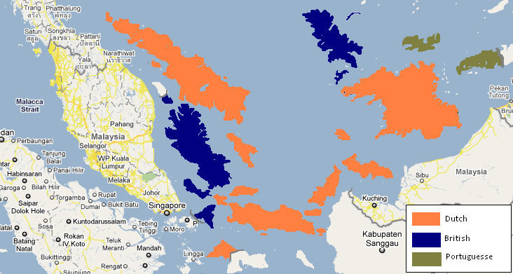
- 1810-1941:
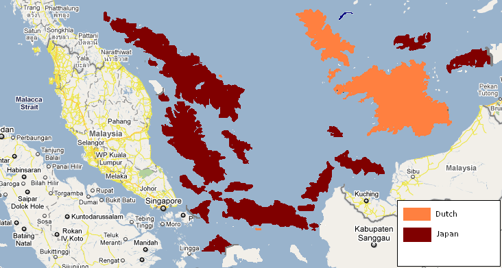
- 1941-1945:
History map after independence:
-1945-1949:
To be continued
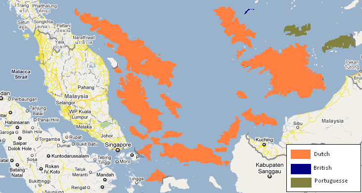
- 1799-1810:
- 1810-1941:
- 1941-1945:
History map after independence:
-1945-1949:
To be continued

Forsma- Prime Minister
- Posts : 2797
Age : 29
-


Blakeway4- International Bigwig
- Posts : 5111
Age : 28

StanislavSoltys- Councillor
- Posts : 291
Age : 28
Re: History and Map
![]() by Forsma 5th March 2011, 18:33
by Forsma 5th March 2011, 18:33
Thanks Julien and Stan! AFNEI is Allied Forces Netherland East Indies
+===========================+
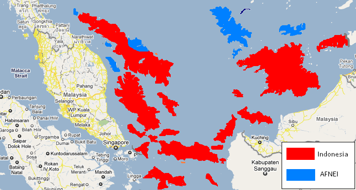
Across independence (1945-1949)
Proclamation of Indonesian Independence in 1945 also include Karasem area to be Indonesian teritory and being a self province, Province of East Malacca (Melaka Timur). Atleast until 3 September 1945, Allied forces arrive in Ketapang. Allied forces was came to returned japanese forces there to their countries and clear the area. However, With British assistance, the Dutch landed their Netherlands Indies Civil Administration (NICA) forces in Meriah and Jayakarta. The republicans didn't accept them and try to resintaced them with former japanese forces's guns.
In 29 October 1945, a resistance attacked allied forces and dutch forces in Suralaya and killed hundrets of them. They were using sharpened bamboo and some japanese rifles to did it. Lateer in 5 November 1945, the payback attack declared by the Allied forces and killed atleast 469 from republicans and 87 from allied forces during the class.
Another resistance was in Cibebek on 15 January 1946 with dutch forces, Pondok Daun on 24 January 1946 also with Dutch and in Kendall on 4 February 1946. More other minor resistance until November 1946 in Melaka Timur. The major one is in Yaharta, 9 November 1946 which killed more than 500 republicans. Respecting to those conflict, the Linggadjati Agreement, also known as the Cheribon Agreement, was a political accord concluded on 15 November 1946 by the Dutch administration and the unilaterally declared Republic of Indonesia. Negotiations took place 11–12 November. The Dutch side was represented by Lieutenant General Governor Hubertus van Mook, the Indonesian side by Prime Minister Sutan Sjahrir. one of the entry was both side would be in ceasefire.
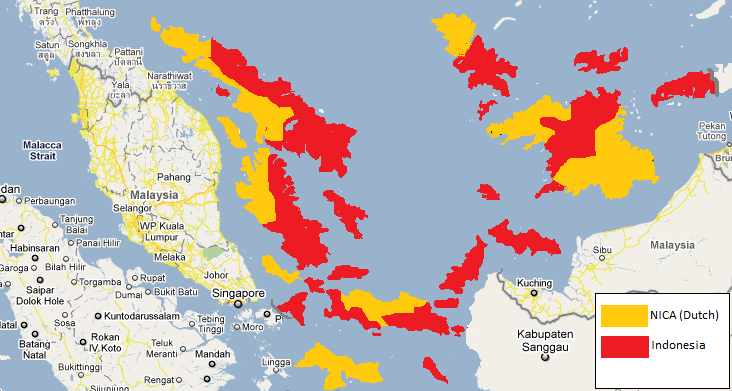
^Karasem's territory after the agreement.
On 25 March 1947 the Lower House of the Dutch parliament ratified a 'stripped down' version of the treaty, which was not accepted by the Republic. Both sides soon accused the other of violating the agreement. At midnight on 20 July 1947, the Dutch launched a major military offensive called Operatie Product, with the intent of conquering the Republic. Claiming violations of the Linggajati Agreement, the Dutch described the campaign as Politionele acties ('police actions') to restore law and order. This used to be the task of the KNIL. However, at the time the majority of the Dutch troops in Indonesia belonged to the Royal Netherlands Army. Soon after the end of WWII, 25,000 volunteers (among them 5,000 marines) had been sent overseas. They were later followed by larger numbers of conscripts from the Netherlands. In the offensive, Dutch forces drove Republican troops out of parts of Sumatra, East and West Java, and Melaka area.
International reaction to the Dutch actions was negative. Neighbouring Australia and newly independent India were particularly active in supporting the Republic's cause in the UN, as was the Soviet Union and, most significantly, the United States. Dutch ships continued to be boycotted from loading and unloading by Australian waterside workers, a blockade that began in September 1945. The United Nations Security Council became directly involved in the conflict, establishing a Good Offices Committee to sponsor further negotiations, making the Dutch diplomatic position particularly difficult. A ceasefire, called for by UN resolution, was ordered by the Dutch and Sukarno on 4 August 1947. The United Nations Security Council brokered the Renville Agreement in an attempt to rectify the collapsed Linggarjati Agreement. The agreement was ratified in January 1948 and recognised a cease-fire along the so-called 'Van Mook line'; an artificial line which connected up the most advanced Dutch positions. one of this areement was to create a new Dutch area named NK (Netherland Karasem) which this lead to the future split between Karasem and Indonesia.

^After Renville agreement
Netherland Karasem was a part of colonies outside dutch teritory. Many area of NK was a no man's land. By July 1948 negotiations were in deadlock and the Netherlands pushed unilaterally towards Van Mook’s concept. Negotiation for NK's possition with Indonesia's side which supported by NK citizens in Kota Meriah sea didn't create any agreement between both sides. So during September-December 1948 the local citizens of Netherland Karasem do full attack to relase NK into Indonesia side, this attack was done in 19 November 1948 which made Ketapang, and Cibebek area taken into NK for 24 hours before the dutch try to finished them. In 20 November 1948 a payback attack from Dutch to the republicans who was taken over NK's government possition. This lead 217 dies and the possition back into dutch hand.

^Karasem in 1949
In 7 Karai operation begun with an attack from Dutch side. The goals was for taken over whole Karaseman's land into NK side not Indonesia side. International reaction to this was a big condemn from UN to Dutch with the embargo of NK governemnt.
Inspired by 'Serangan Oemoem 1 Maret' in Yogyakarta, the last power of republicans try to taken over the Meriah from NK. The Dutch were expelled from the city for 18 hours but reinforcements were brought in from the nearby cities of Kemayoran and Cakung that afternoon. This attack leaded by General Ahmad Amril i from 7.00 am until 1.00 am next day.
The final of these things is the Independence admission from Dutch for Netherland Karasem which changed into Karasem in 27 December 1949. The territory of the Karasem at thet time is all current territory excluding North Karasem Province.
^Karasem's territory in admission
+===========================+
Across independence (1945-1949)
Proclamation of Indonesian Independence in 1945 also include Karasem area to be Indonesian teritory and being a self province, Province of East Malacca (Melaka Timur). Atleast until 3 September 1945, Allied forces arrive in Ketapang. Allied forces was came to returned japanese forces there to their countries and clear the area. However, With British assistance, the Dutch landed their Netherlands Indies Civil Administration (NICA) forces in Meriah and Jayakarta. The republicans didn't accept them and try to resintaced them with former japanese forces's guns.
In 29 October 1945, a resistance attacked allied forces and dutch forces in Suralaya and killed hundrets of them. They were using sharpened bamboo and some japanese rifles to did it. Lateer in 5 November 1945, the payback attack declared by the Allied forces and killed atleast 469 from republicans and 87 from allied forces during the class.
Another resistance was in Cibebek on 15 January 1946 with dutch forces, Pondok Daun on 24 January 1946 also with Dutch and in Kendall on 4 February 1946. More other minor resistance until November 1946 in Melaka Timur. The major one is in Yaharta, 9 November 1946 which killed more than 500 republicans. Respecting to those conflict, the Linggadjati Agreement, also known as the Cheribon Agreement, was a political accord concluded on 15 November 1946 by the Dutch administration and the unilaterally declared Republic of Indonesia. Negotiations took place 11–12 November. The Dutch side was represented by Lieutenant General Governor Hubertus van Mook, the Indonesian side by Prime Minister Sutan Sjahrir. one of the entry was both side would be in ceasefire.
^Karasem's territory after the agreement.
On 25 March 1947 the Lower House of the Dutch parliament ratified a 'stripped down' version of the treaty, which was not accepted by the Republic. Both sides soon accused the other of violating the agreement. At midnight on 20 July 1947, the Dutch launched a major military offensive called Operatie Product, with the intent of conquering the Republic. Claiming violations of the Linggajati Agreement, the Dutch described the campaign as Politionele acties ('police actions') to restore law and order. This used to be the task of the KNIL. However, at the time the majority of the Dutch troops in Indonesia belonged to the Royal Netherlands Army. Soon after the end of WWII, 25,000 volunteers (among them 5,000 marines) had been sent overseas. They were later followed by larger numbers of conscripts from the Netherlands. In the offensive, Dutch forces drove Republican troops out of parts of Sumatra, East and West Java, and Melaka area.
International reaction to the Dutch actions was negative. Neighbouring Australia and newly independent India were particularly active in supporting the Republic's cause in the UN, as was the Soviet Union and, most significantly, the United States. Dutch ships continued to be boycotted from loading and unloading by Australian waterside workers, a blockade that began in September 1945. The United Nations Security Council became directly involved in the conflict, establishing a Good Offices Committee to sponsor further negotiations, making the Dutch diplomatic position particularly difficult. A ceasefire, called for by UN resolution, was ordered by the Dutch and Sukarno on 4 August 1947. The United Nations Security Council brokered the Renville Agreement in an attempt to rectify the collapsed Linggarjati Agreement. The agreement was ratified in January 1948 and recognised a cease-fire along the so-called 'Van Mook line'; an artificial line which connected up the most advanced Dutch positions. one of this areement was to create a new Dutch area named NK (Netherland Karasem) which this lead to the future split between Karasem and Indonesia.
^After Renville agreement
Netherland Karasem was a part of colonies outside dutch teritory. Many area of NK was a no man's land. By July 1948 negotiations were in deadlock and the Netherlands pushed unilaterally towards Van Mook’s concept. Negotiation for NK's possition with Indonesia's side which supported by NK citizens in Kota Meriah sea didn't create any agreement between both sides. So during September-December 1948 the local citizens of Netherland Karasem do full attack to relase NK into Indonesia side, this attack was done in 19 November 1948 which made Ketapang, and Cibebek area taken into NK for 24 hours before the dutch try to finished them. In 20 November 1948 a payback attack from Dutch to the republicans who was taken over NK's government possition. This lead 217 dies and the possition back into dutch hand.
^Karasem in 1949
In 7 Karai operation begun with an attack from Dutch side. The goals was for taken over whole Karaseman's land into NK side not Indonesia side. International reaction to this was a big condemn from UN to Dutch with the embargo of NK governemnt.
Inspired by 'Serangan Oemoem 1 Maret' in Yogyakarta, the last power of republicans try to taken over the Meriah from NK. The Dutch were expelled from the city for 18 hours but reinforcements were brought in from the nearby cities of Kemayoran and Cakung that afternoon. This attack leaded by General Ahmad Amril i from 7.00 am until 1.00 am next day.
The final of these things is the Independence admission from Dutch for Netherland Karasem which changed into Karasem in 27 December 1949. The territory of the Karasem at thet time is all current territory excluding North Karasem Province.
^Karasem's territory in admission
Forsma- Prime Minister
- Posts : 2797
Age : 29 -
Re: History and Map
![]() by Blakeway4 5th March 2011, 19:41
by Blakeway4 5th March 2011, 19:41
Wow, very detailed, lovely maps and great job! 
Blakeway4- International Bigwig
- Posts : 5111
Age : 28
Re: History and Map
![]() by Forsma 6th March 2011, 07:40
by Forsma 6th March 2011, 07:40
Thanks Julien!  TThis should be the important part of Karasem's history...
TThis should be the important part of Karasem's history...
Forsma- Prime Minister
- Posts : 2797
Age : 29 -
» Pavillions | Tirnreich
» Rhodes V1 Forum
» History of Cattala
» Shuto Empire Archives
» History and Colonization
» Rhodes V1 Forum
» History of Cattala
» Shuto Empire Archives
» History and Colonization
Page 1 of 1
Permissions in this forum:
You cannot reply to topics in this forum|
|
|