Map of AIN Version 2
+10
woodb3kmaster
Sky Guy
Saathoff
Thomas
Neil
Matt
emgmod
Daniel
Blakeway4
Aranho
14 posters
Page 1 of 2
Page 1 of 2 • 1, 2 
 Map of AIN Version 2
As promised during the First AIN-LON Inter-Union Meeting, I will be making a map for the Alliance of Independent Nations. Although I am not sure if this is neccessary now due to the creation of New Eden, I will be doing this until further notice.
Basically, all I need is two maps from you: city map and location map.
City Map
A small-scale country map with any major cities listed, including the capital of the country.
Location Map
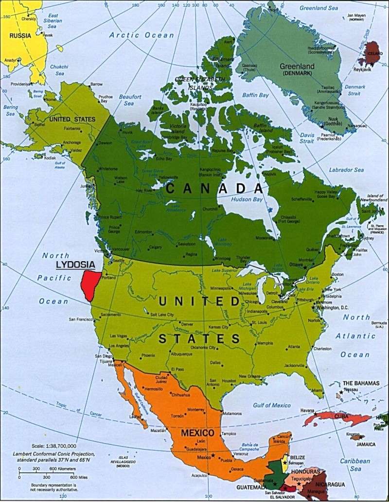
A large-scale map of your country big enough for me to determine the exact and correct location of your country on the World Map. It is recommended that the Location Map is shown on a Continent Map and not either a Map of the Whole World or a Map of just your country.
Using the KISS method, just fill up the form below:
Username:
City Map:
Location Map:

Aranho- Sovereign
- Posts : 3602

 Re: Map of AIN Version 2
Username: Blakeway
City Map:
Top at right is Prodisiac, left top is Makadewa, midle near the Volcano is St-Mathieu, at the bottom of St-Mathieu at left is Baie-des-Rochers, at the right with a big lake is Rollet, on the south of Lydosia is Nigamo, with the big Nigamo Lake.
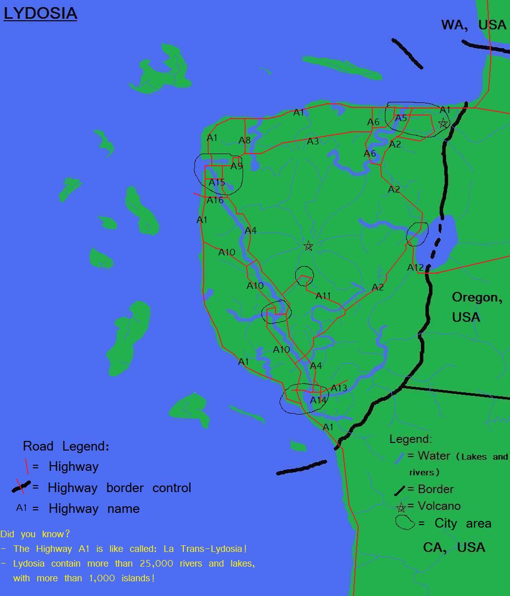
Location Map:
City Map:
Top at right is Prodisiac, left top is Makadewa, midle near the Volcano is St-Mathieu, at the bottom of St-Mathieu at left is Baie-des-Rochers, at the right with a big lake is Rollet, on the south of Lydosia is Nigamo, with the big Nigamo Lake.

Location Map:


Blakeway4- International Bigwig
- Posts : 5111
Age : 29
 Re: Map of AIN Version 2
ARCACIA - 16km (10 miles) across
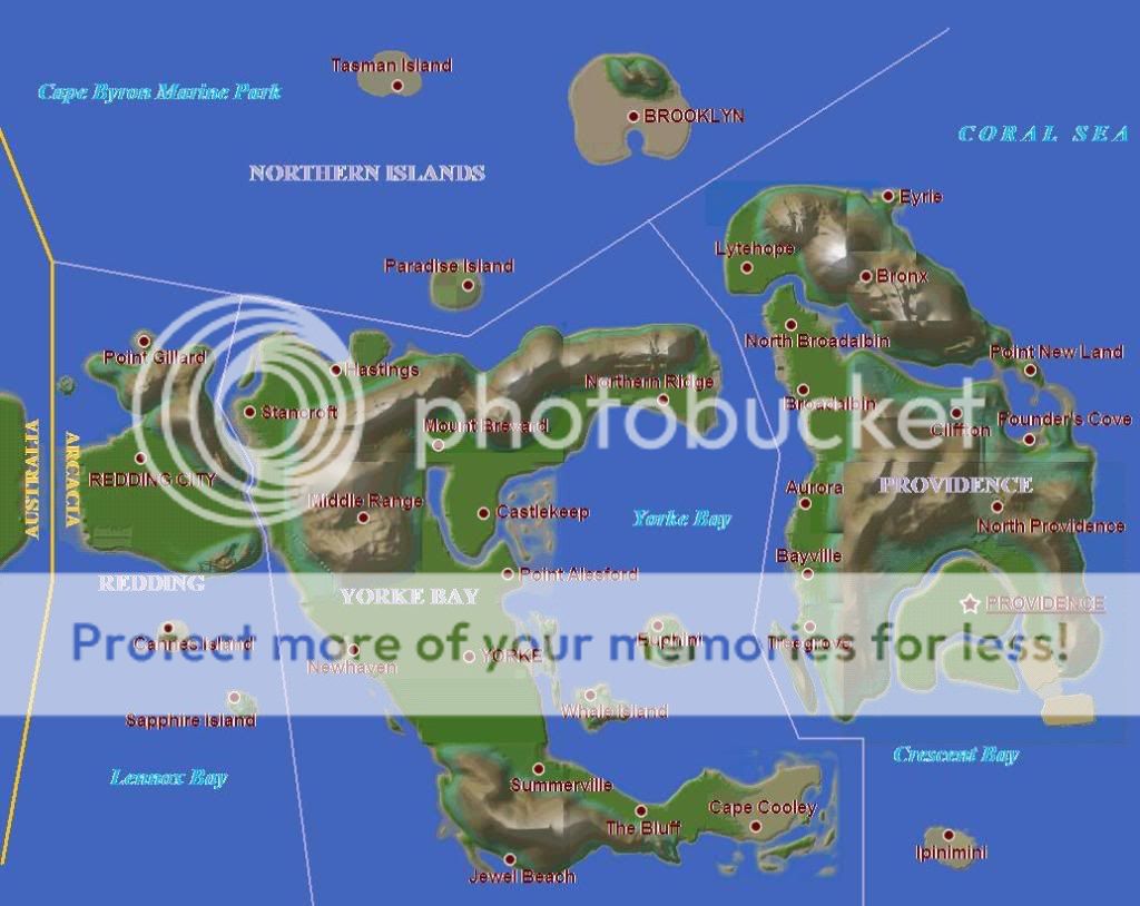
LYCANTHIA - 2km (1.25 miles) across


LOCATIONS - Both would appear as dots on a global map:
- Arcacia: South of Byron Bay, between Lennox Head and Ballina
- Lycanthia: 42km South of Yamba, off the coast 1km South of Digger's Camp and 38km East-South-East of Grafton, or 114km South of Arcacia

LYCANTHIA - 2km (1.25 miles) across


LOCATIONS - Both would appear as dots on a global map:
- Arcacia: South of Byron Bay, between Lennox Head and Ballina
- Lycanthia: 42km South of Yamba, off the coast 1km South of Digger's Camp and 38km East-South-East of Grafton, or 114km South of Arcacia

Daniel- On Leave
- Posts : 2333
Age : 45
 Re: Map of AIN Version 2
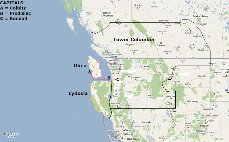
This isn't final, as Illu'a probably has overlapping borders with Lydosia. We'll solve that later.
Username: emgmod
City Map: Major highways are marked in yellow. Freeways aren't very common.

Location Map:

Username: emgmod
City Map: Major highways are marked in yellow. Freeways aren't very common.

Location Map:


emgmod- High Commissioner
- Posts : 1536

 Re: Map of AIN Version 2
emgmod wrote:This isn't final, as Illu'a probably has overlapping borders with Lydosia. We'll solve that later.
Yeah!
 There's a little problem ya
  Perhaps, I'm sure we could have a fair deal!
Blakeway4- International Bigwig
- Posts : 5111
Age : 29
 Re: Map of AIN Version 2
Username: Neil
City Map: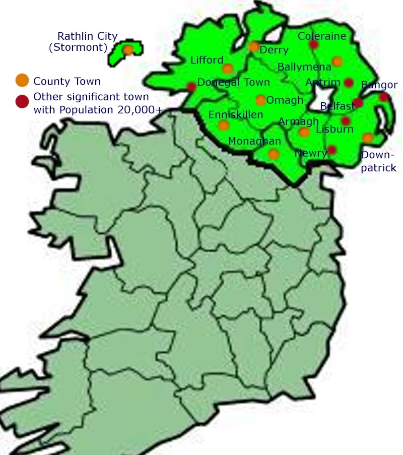
**The Only Important cities are (In Order): Rathlin, Belfast, Derry, Newry and perhaps Lisburn and Armagh
Location Map: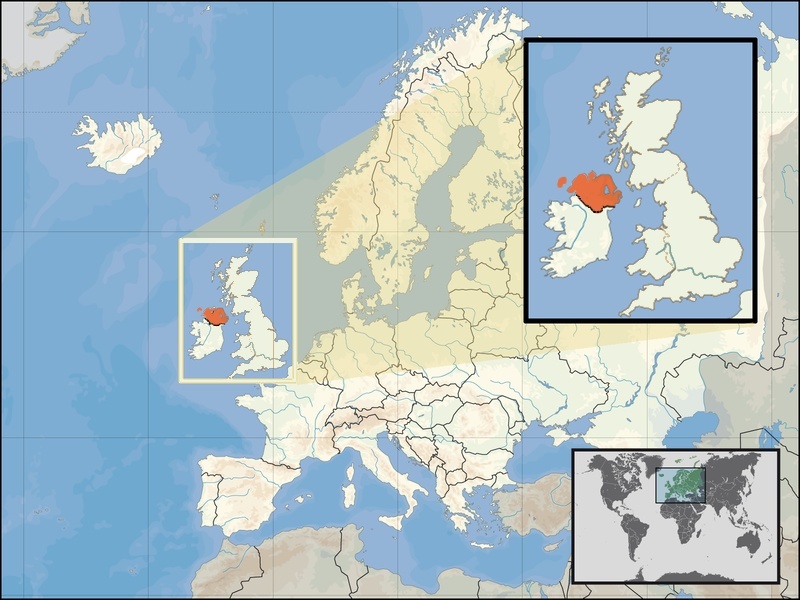
Holidia also has 4 other small island territories but they are all extremly small (2sqmi, 17sqmi, 29sqmi and 33sqmi) and unimportant in a global scale...
City Map:

**The Only Important cities are (In Order): Rathlin, Belfast, Derry, Newry and perhaps Lisburn and Armagh
Location Map:

Holidia also has 4 other small island territories but they are all extremly small (2sqmi, 17sqmi, 29sqmi and 33sqmi) and unimportant in a global scale...
 Re: Map of AIN Version 2
Thank you all guys for sending in your forms. I will begin vreating on these ASAP.

Aranho- Sovereign
- Posts : 3602

 Re: Map of AIN Version 2
*Bump*
Country Name: United Islands of Ollingdale (Ollingdale)
Continent Map:
Country Map:
Country Name: United Islands of Ollingdale (Ollingdale)
Continent Map:

Country Map:

Last edited by Thomas on 28th February 2010, 10:31; edited 2 times in total

Thomas- Overlord of Eurasia
- Posts : 5849

 Re: Map of AIN Version 2
i can prolly get this done sometime. Not sure when

Saathoff- Prime Minister
- Posts : 2373

 Re: Map of AIN Version 2
That reminds me... there's an updated map of the Pacific northwest. I will explain the red lines later.


emgmod- High Commissioner
- Posts : 1536

 Re: Map of AIN Version 2
Opps. I've forgotten about this.
I'll work on this right away.
I'll work on this right away.

Aranho- Sovereign
- Posts : 3602

 Re: Map of AIN Version 2
Please submit your map if you haven't. This includes ALL AIN members, ranging from Petrova to Escambia, from Hypertrophy to Aleksania.
Basically, all I need is two maps from you: city map and location map.
City Map
A small-scale country map with any major cities listed, including the capital of the country.
Location Map
A large-scale map of your country big enough for me to determine the exact and correct location of your country on the World Map. It is recommended that the Location Map is shown on a Continent Map and not either a Map of the Whole World or a Map of just your country.
Using the KISS method, just fill up the form below:
Username:
City Map:
Location Map:

Aranho- Sovereign
- Posts : 3602

 Re: Map of AIN Version 2
Aran, is it ok if Emgmod, Wood and I are using the Pacific Northwest Map that emgmod posted just above? Or do you want us to put the cities also? Well here is it with the cities:


Blakeway4- International Bigwig
- Posts : 5111
Age : 29
 Re: Map of AIN Version 2
It's alright. Since both Illu'a and Lydosia have their city map above. I need the city map for Lower Columbia though, unless those real world cities on that map are part of Lower Columbia.

Aranho- Sovereign
- Posts : 3602

 Re: Map of AIN Version 2
The Lower Columbia map is that one:

So there's all the current RL cities + the 2 mentionned

So there's all the current RL cities + the 2 mentionned

Blakeway4- International Bigwig
- Posts : 5111
Age : 29
 Re: Map of AIN Version 2
Ok heres me:
Sultanate of Bangorai'


Cities:

Sultanate of Bangorai'


Cities:


Sky Guy- Chargé d'Affaires
- Posts : 1185
Age : 31
 Re: Map of AIN Version 2
They are, in fact, part of Lower Columbia. For my borders, though, go with the Google Earth screenshot Blakeway posted, keeping in mind that the curved lines aren't really curved (that is, they follow real lines of latitude/longitude).Aranho wrote:I need the city map for Lower Columbia though, unless those real world cities on that map are part of Lower Columbia.

woodb3kmaster- Permanent Secretary
- Posts : 583
Age : 38
 Re: Map of AIN Version 2
I will post my pics soon. I dont have access to my computer right now.

Liberater444- Ambassador At Large
- Posts : 1432

 Re: Map of AIN Version 2
I believe Nate will do doing it now since I've neglected it, cuz Nate recently (for my case) sent me a PM of a high quality map of my country.

Aranho- Sovereign
- Posts : 3602

 Re: Map of AIN Version 2
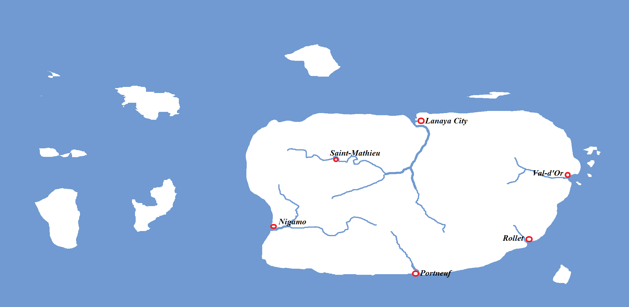
Well, please delete Lydosia for all the further map  thank you and add Lanaya, here's the location:

Edited
 thank you and add Lanaya, here's the location:

Edited
Last edited by Blakeway on 1st April 2010, 23:25; edited 1 time in total

Blakeway4- International Bigwig
- Posts : 5111
Age : 29
 Re: Map of AIN Version 2
976 wrote:-Bump-
Any news of AIN map?
Well i sent you a pm. You need to reply your map to me

Saathoff- Prime Minister
- Posts : 2373

Page 1 of 2 • 1, 2 
 Similar topics
» Map of AIN Version 3
» Map of AIN Version 5
» AIN Flag Pack (Version 2)
» AIN WORLD MAP 2011 - Official PNG blank map version
» Map of AIN Version 5
» AIN Flag Pack (Version 2)
» AIN WORLD MAP 2011 - Official PNG blank map version
Page 1 of 2
Permissions in this forum:
You cannot reply to topics in this forum


